This is my note for lesson 3 of MOOC course: Self-Driving Fundamentals - Featuring Apollo. Content: How the vehicle localizes itself with a single-digit-centimeter-level accuracy.
1 Localization methods in Apollo
- The RTK (Real Time Kinematic) based method which incorporates GPS and IMU (Inertial Measurement Unit) information.
- The multi-sensor fusion method which incorporates GPS, IMU, and LiDAR information.
2 Inertial navigation
Global Navigation Satellite System (GNSS)
Global Navigation Satellite System (GNSS) refers to a constellation of satellites providing signals from space that transmit positioning and timing data to GNSS receivers. The receivers then use this data to determine location. Global Positioning System (GPS) is a kind of GNSS.
Properties:
- Accurate with RTK
- Poor performance in urban area and canyons
- Low frequency update (~10Hz) ➝ Too slow for realtime positioning on SDC.
Inertial Measurement Unit (IMU)
On Wikipedia: An inertial measurement unit (IMU) is an electronic device that measures and reports a body's specific force, angular rate, and sometimes the orientation of the body, using a combination of accelerometers, gyroscopes, and sometimes magnetometers.
Components of IMU:
- Accelerometer: measures velocity and acceleration
- Gyroscope: measures rotation and rotational rate
- Magnetometer: establishes cardinal direction (directional heading)
Disadvantage: The IMU's motion error increase with time.
GPS + IMU
We can combine GPS + IMU to localize the car. On one hand, IMU compensates for the low update frequency of GPS. On the other hand, GPS corrects the IMU's motion errors.
3 LiDAR Localization
With LiDAR, we can localize a car by means of point cloud matching. This method continuously matches the detected data from LiDAR sensors with the preexisting HD map. ➝ Require constantly updated HD map ➝ Very difficult.
4 Visual localization
Can we use images from cameras to localize the car?
Yes, but using only camera is hard. We often combine images with other sensor signals.
Particle Filter: We use particles or points on the map to estimate our most likely location.
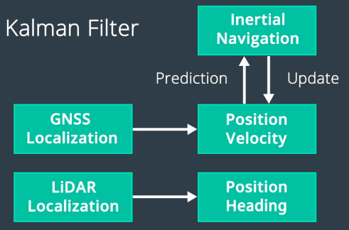
5 Apollo Localization
Apollo localization using input from multiple sources and use Kalman Filter for sensor fusion.
6 Kidnapped Vehicle
TODO: Try Kidnapped Vehicle Project.